Mount Agung eruption
2018
Mount Agung eruption update 3 July: Agung erupted again due to a minor strombolian explosion. 700 people living near the crater were evacuated. No flights were affected.
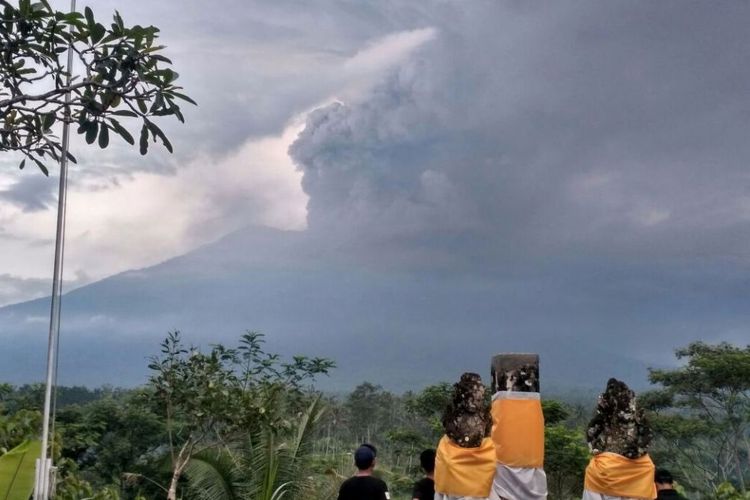
Mount Agung eruption update 29 June: The Agung volvano is sending water vapor and hot volcanic ash 2,500 meters into the air following an eruption on Thursday, causing major disruption to international flights. The international Airport of Bali, Ngurah Rai Denpasar airport, was shut down at 3.00 on June 29 local time (8.00pm June 28 GMT) due to the lack of visibility provoked by the ash cloud.
Mount Agung eruption update 1o February: Thousands of people who were forced to evacuate their houses in the exclusion zone of the Agung volcano are allowed to go home, following the lowering of the alert level by the authorities.
Mount Agung eruption update 15 January: A minor eruption occurred in the morning hours. Mount Agung sent a grey ash plume of 2,000m into the sky. The exclusion zone is still set at a radius of six kilometers from Agung’s crater. The rest of Bali is safe. The airport of Bali remains fully operational.
Mount Agung eruption update 11 January: A minor eruption occurred, Mount Agung sent an ash plume of 2,500m into the sky. As the impact of this eruption was far less than the November eruption, the airport of Bali remains fully operational.
2017
Mount Agung eruption update 24 December: Authorities declared Bali is back to normal apart from the 10 KM hazard zone surrounding Mount Agung.
Mount Agung eruption update 11 December: Two more minor eruptions occurred in the morning hours, causing an ash plume of 3 km into the sky.
Mount Agung eruption update 8 December: In the morning hours there was a third minor eruption. The volcano coughed out of ash plume 2 km into the sky.
Mount Agung eruption update 5 December: The Agung volcano has calmed down in the recent days. Flights have returned to normal schedules and tourism is starting up again. Indonesia’s disaster mitigation agency said Monday that although the volcano remains at its highest alert level, 98 percent of Bali is safe for tourists. The only dangerous area is the exclusion zone around the volcano, which extends 10 kilometers from the crater.
Mount Agung eruption update 29 November: The airport will open again 3 pm on Wednesday (0700 GMT) Reuters reported.
Mount Agung eruption update 28 November: The airport will stay closed at least until 7 am on Thursday (2300 GMT), the transport ministry said.
Mount Agung eruption update 27 November: Because of the eruption of Mount Agung tens of thousands of travelers have stranded on Bali as the airport is closed until at least Wednesday morning.
Mount Agung eruption update 26 November: The eruption of Mount Agung has changed overnight from a phreatic eruption – in which water is heated by magma – to a magmatic eruption. A larger eruption could be imminent. The island’s airport has been closed.
Mount Agung eruption update 25 November: Since the minor eruption of November 21st the Agung volcano has erupted again and continues to emit ash. The ash cloud already reaches tens of kilometers covering parts of Karangasem and Klunkung.
(Kompa.com/ Robinson Gamar)
Mount Agung eruption update 24 November: The Centre for Volcanology and Geological Hazards (PVMBG) flew a drone over Mount Agung’s crater in Bali on Friday. During its flight, a red spot was detected which could be magma that has reached the surface. It still needs further research, however, before this can be confirmed.
Mount Agung eruption update 21 November: Smoke and ash emitted from the Mount Agung volcano in East Bali. The minor eruption formed an ash cloud 700 meters above the volcanic peak.There had not been an increase in the frequency of volcanic tremors, however. The alert level remained at three, having been downgraded on 29 October.
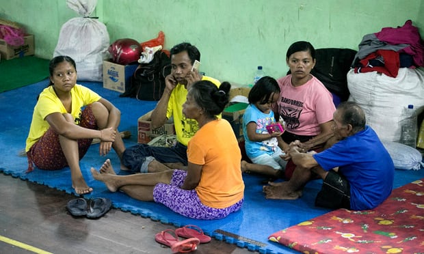
The mount Agung volcano shows heightened volcanic activity since the end of September 2017. The authorities ordered more than 100,000 people living within the designated danger zone (within a radius of 6-7.5km around the volcano) to leave their homes. As a result, around 30,000 people remain in camps and shelters all over the island.
1963 eruption of Mount Agung
Mount Agung volcano has last erupted in the year 1963. This eruption was one of the largest and most devastating eruptions in Indonesia’s history.
On February 18, 1963, the eruption started with loud bangs saw thick clouds rising from the crater of Mount Agung. On February 24, lava started to flow down the northern slope of the mountain. The lava travelled about 7 km in the next 20 days. On March 17, the volcano eventually erupted, sending debris 8 to 10 km into the air and generating massive pyroclastic flows. This destroyed many villages and killed about 1,100—1,500 people. A second eruption on May 16 killed another 200 people. Minor eruptions and flows followed and lasted almost a year.
Miraculously the lava flows missed, sometimes by mere yards, the Mother Temple of Besakih. The saving of the temple is regarded by Balinese as a signal from the gods that they wished to demonstrate their power but not destroy the monument that the Balinese had erected.
(source: Wikipedia)
Bali’s Ngurah international airport in South Bali is operating as normal.
Mount Batur, Bali’s other active volcano, does not show any heightened activity.
share this Mount Agung eruption page